
Mount Haku
| Mount Haku | |
|---|---|
 Mount Haku seen from Onanjimine | |
| Highest point | |
| Elevation | 2,702.2 m (8,865 ft)[1] |
| Prominence | 1,897 m (6,224 ft)[1] |
| Listing | |
| Coordinates | 36°09′18″N 136°46′17″E / 36.15500°N 136.77139°E[1] |
| Naming | |
| English translation | White Mountain |
| Language of name | Japanese |
| Pronunciation | [hakɯ̥saɴ] |
| Geography | |
 Mount Haku Location in Japan | |
| Location | |
| Parent range | Ryōhaku Mountains |
| Topo map | Geographical Survey Institute, 25000:1 |
| Geology | |
| Age of rock | 300,000–400,000 years |
| Mountain type | Stratovolcano (active) |
| Last eruption | April to August 1659 |
| Climbing | |
| First ascent | Taichō in 717 |
Mount Haku (
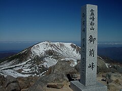
The mountain's tallest peak, Gozenga-mine (
Because it is very prominent and clearly visible from the nearby coast, even after the surrounding mountains have lost their snow, Mount Haku still appears white, which is one explanation for the mountain's name, which means "white mountain." It is also the westernmost mountain in Japan that is over 2,000 m (6,562 ft) in height.
History and culture
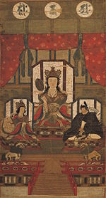
[edit]Taichō, a mountain Shugendo monk, first climbed Mount Hakusan in 717. For hundreds of years, people have come to Haku for prayers (
Nature
[edit]Mount Haku was designated as a quasi-national park in 1955. It became a national park in 1962[3] and was renamed Hakusan National Park. Because the central part of the mountain has much precipitous terrain, there are very few roads and, as a result, little human intrusion into the area. Also limiting human intrusion is the designation of the park as a Wildlife Protection Area, covering over 38,061 ha. The park stretches beyond the mountain's borders into Toyama Prefecture.[3]
Geological features
[edit]The area surrounding Mount Haku is one of the few in Japan that contains outcroppings from the Jurassic period of the Mesozoic era. Many of Japan's typical examples of dinosaur fossils were found in this area. One of the major rock outcrops is in the Kuwashima area and is known as the "Kuwashima Fossil Wall" (
Because the mountain is a dormant volcano, it is well known for its many onsen.
Flora
[edit]Mount Haku is known for its diverse plant life. Along the Sabō Trail, after passing the Jinnosuke Lodge, alpine plants are found, including the chocolate lily, which is Ishikawa's prefectural plant.
There are many alpine plants which have Hakusan in their name. These include Primula cuneifolia (Hakusan Kozakura), Anemone narcissiflora (Hakusan Ichige), Dactylorhiza (Hakusan Chidori), Geranium yesoemse (Hakusan Fuuro) and Rhododendron brachycarpum (Hakusan Shakunage). These plants can be found on many mountains throughout Japan, but they were first discovered and named along the older hiking trails leading to Hakusan Shrine.
| Chocolate lily (Kuro Yuri) |
Primula cuneifolia (Hakusan Kozakura) |
Anemone narcissiflora (Hakusan Ichige) |
Dactylorhiza aristata (Hakusan Chidori) |
|---|---|---|---|

|

|

|

|
Fauna
[edit]The golden eagle, Ishikawa's prefectural bird, lives on the slopes of Mount Haku. The rock ptarmigan, Gifu's prefectural bird,[5] used to live on the slopes as well. During the Meiji period, the entire population of ptarmigan on the mountain disappeared; however, sightings of the grouse have recently been recorded by local residents.
Hiking trails
[edit]The three most used hiking trails are the Kankō Trail (
Because the area is protected as a national park, very few trails have been made on the mountain. Though the trails listed above are easy enough to hike up and down in one day, other trails can take two or three days because of the uncleared trails and rough terrain.
Gallery
[edit]-
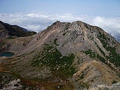
 Top of Gozengamine (Mount Haku) and Ōnanjimine
 -
 Hakusan Shrine at Murodo and Gozengamine
 -
 Volcanic crater (Midoriga-ike)
 -
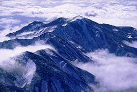
 Mount Haku in each season
 -
 Mount Haku from Midagahara
 -
 Kengamine Peak from Gozengamine Peak
 -
 Mount Haku from east of Mount Hideri
 -
 Mount Bessan from the top of Gozengamine


See also
[edit]- Hakusan National Park
- Ryōhaku Mountains
- List of volcanoes in Japan
- List of mountains in Japan
- Taichō
References
[edit]- ^ a b c "Japan Ultra-Prominences". Peaklist.org. Retrieved 2015-01-01.
- ^
白山 のなりたち、信仰 の歴史 を簡単 に紹介 します。 [A brief introduction to the origins of Mt. Hakusan and the history of the faith.]. Hakusan Wide Area Tourism Promotion Council Website [Gurutto Hakusan] (in Japanese). Archived from the original on 21 September 2010. - ^ a b c UNESCO Biosphere Reserve Information: Mount Hakusan. UNESCO. Accessed May 16, 2008.
- ^ "Biosphere Reserve Information - Mount Hakusan". UNESCO. Retrieved 29 April 2011.
- ^ A Statistical Guide to Gifu Prefecture 2007 Archived 2009-03-25 at the Wayback Machine. Gifu Prefecture. Accessed May 16, 2008.
External links
[edit]- Hakusan - Japan Meteorological Agency (in Japanese)
- "Hakusan: National catalogue of the active volcanoes in Japan" (PDF). - Japan Meteorological Agency
- Hakusan - Geological Survey of Japan
- "Hakusan". Global Volcanism Program. Smithsonian Institution. Retrieved 2021-06-24.
| Hokkaidō | |||||||||
|---|---|---|---|---|---|---|---|---|---|
| Tōhoku region Jōshinetsu region |
| ||||||||
| Kantō region | |||||||||
| Chūbu region |
| ||||||||
| Western Japan | |||||||||
| |||||||||
| International | |
|---|---|
| National | |
| Geographic | |
| Main Deities |
|  |
|---|---|---|
| Head Shrines | ||
| Branch shrines | ||
- Volcanoes of Honshū
- Mountains of Gifu Prefecture
- Mountains of Ishikawa Prefecture
- Mountains of Fukui Prefecture
- Two-thousanders of Asia
- Biosphere reserves of Japan
- Cultural Landscapes of Japan
- Volcanoes of Gifu Prefecture
- Volcanoes of Ishikawa Prefecture
- Volcanoes of Fukui Prefecture
- Potentially active volcanoes
- Pleistocene stratovolcanoes
- Pleistocene Asia
- Cenozoic Japan
- Sacred mountains of Japan
- Shugendō
- Highest points of Japanese national parks