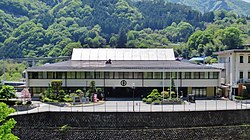
Ueno, Gunma
This article needs additional citations for verification. (April 2015) |
Ueno
| |
|---|---|
 Ueno village office | |
 Location of Ueno in Gunma Prefecture | |
| Coordinates: 36°4′59.5″N 138°46′38.3″E / 36.083194°N 138.777306°E | |
| Country | Japan |
| Region | Kantō |
| Prefecture | Gunma |
| District | Tano |
| Area | |
| • Total | 181.85 km2 (70.21 sq mi) |
| Population (October 1, 2020) | |
| • Total | 1,149 |
| • Density | 6.3/km2 (16/sq mi) |
| Time zone | UTC+9 (Japan Standard Time) |
| Phone number | 0274-59-2111 |
| Address | 11 Kawawa, Ueno-mura, Tano-gun, Gunma-ken 370–1614 |
| Website | Official website |
Ueno (
Geography
[edit]Ueno is located in the extreme mountainous southwestern portion of Gunma Prefecture, bordered by Saitama Prefecture to the south and Nagano Prefecture to the west.
- Mountains
- Mount Suwa
- Mount Osutaka (1639m)
- Mount Takamagahara (1979m)
- Rivers
- Kanna River
Surrounding municipalities
[edit]Climate
[edit]Ueno has a Humid continental climate (Köppen Dfb) characterized by warm summers and cold winters with heavy snowfall. The average annual temperature in Ueno is 8.0 °C. The average annual rainfall is 1479 mm with September as the wettest month. The temperatures are highest on average in August, at around 20.6 °C, and lowest in January, at around -4.2 °C.[2]
Demographics
[edit]Per Japanese census data,[3] the population of Ueno peaked in the 1950s and is now only a quarter of what it was a century ago.
| Year | Pop. | ±% |
|---|---|---|
| 1920 | 4,423 | — |
| 1930 | 3,895 | −11.9% |
| 1940 | 3,887 | −0.2% |
| 1950 | 4,721 | +21.5% |
| 1960 | 4,299 | −8.9% |
| 1970 | 2,996 | −30.3% |
| 1980 | 2,309 | −22.9% |
| 1990 | 1,711 | −25.9% |
| 2000 | 2,285 | +33.5% |
| 2010 | 1,306 | −42.8% |
| 2020 | 1,128 | −13.6% |
History
[edit]During the Edo period, the area of present-day Ueno was part of the tenryō territory administered directly by the Tokugawa shogunate in Kōzuke Province.
Ueno village was established within Minamikanra District, Gunma Prefecture on April 1, 1889, with the creation of the modern municipalities system after the Meiji Restoration. In 1896, Minamikanra District was united with Midono and Tago Districts to create Tano District. On August 12, 1985, Japan Airlines Flight 123, heading from Haneda Airport to Itami Airport, crashed into an area within the Ueno Village limits, killing 520 people in the world's deadliest single-aircraft aviation accident.[4]
The village rejected the central's governments directives on Municipal mergers and dissolutions in Japan. Despite its depopulation, revenue from Ueno Dam and the Tokyo Electric Kannagawa Power Station give the local government the highest financial strength index in the prefecture.
Government
[edit]Ueno has a mayor-council form of government with a directly elected mayor and a unicameral town council of eight members. Ueno, together with the city of Fujioka and village of Ueno contributes two members to the Gunma Prefectural Assembly. In terms of national politics, the town is part of Gunma 4th district of the lower house of the Diet of Japan.
Economy
[edit]The economy of Ueno is heavily dependent on agriculture and forestry.
Education
[edit]Ueno has one public elementary school and one public middle school operated by the village government.[5] The village does not have a high school.
Transportation
[edit]Railway
[edit]Ueno does not have any passenger railway service.
Bus
[edit]Ueno Village Bus comes from Joshin Electric Railway Shimonita Station, and Nippon Chuo Bus Okutano Line comes from JR East Shinmachi Station (Gunma)
Highway
[edit]International relations
[edit]Local attractions
[edit]
- Shionosawa Onsen
- Ueno Dam
- Ueno Sky Bridge - The Ueno skybridge is a 225 metre long pedestrian suspension bridge. At a height of 90 metres, it offers scenic views.[6][7]
References
[edit]- ^ "Ueno Village official statistics" (in Japanese). Japan.
- ^ Ueno climate data
- ^ Ueno population statistics
- ^ "Aircraft Accident Investigation Report Japan Air Lines Co., Ltd. Boeing 747 SR-100, JA8119 Gunma Prefecture, Japan August 12, 1985." 8 (19/332). Retrieved on August 18, 2010.
- ^ "
学校 教育 ". Ueno Village. Retrieved 2019-10-19. - Ueno Elementary homepage and Ueno Junior High homepage - ^ "Ueno Sky Bridge". Gunma Official Tourist Guide. Tourism Value Creation Division, Gunma Prefectural Government. Retrieved 9 July 2024.
- ^
上野 スカイブリッジ (in Japanese). Ueno Village Office. Retrieved 9 February 2019.
External links
[edit]![]() Media related to Ueno, Gunma at Wikimedia Commons
Media related to Ueno, Gunma at Wikimedia Commons
- Official Website (in Japanese)


