Wufeng Tujia Autonomous County
Appearance
Wufeng County
| |
|---|---|
| 五峰土家族自治县 Wufeng Tujia Autonomous County | |
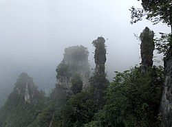
 Wufeng Chai Buxi Grand Canyon Scenic Spot | |
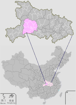
 Wufeng is the southernmost division on this map of Yichang | |
 Yichang in Hubei | |
| Coordinates: 30°09′25″N 111°04′26″E / 30.157°N 111.074°E | |
| Country | People's Republic of China |
| Province | Hubei |
| Prefecture-level city | Yichang |
| Area | |
| • Total | 2,401 km2 (927 sq mi) |
| Population (2010)[1] | |
| • Total | 188,923 |
| • Density | 79/km2 (200/sq mi) |
| Time zone | UTC+8 (China Standard) |
| Website | www |
Wufeng Tujia Autonomous County (simplified Chinese:
Administrative divisions
[edit]Three townships:
Climate
[edit]| Climate data for Wufeng, elevation 751 m (2,464 ft), (1994–2017 normals, extremes 1981–2010) | |||||||||||||
|---|---|---|---|---|---|---|---|---|---|---|---|---|---|
| Month | Jan | Feb | Mar | Apr | May | Jun | Jul | Aug | Sep | Oct | Nov | Dec | Year |
| Record high °C (°F) | 22.4 (72.3) |
26.7 (80.1) |
34.8 (94.6) |
36.9 (98.4) |
36.8 (98.2) |
37.2 (99.0) |
38.6 (101.5) |
38.4 (101.1) |
39.2 (102.6) |
33.9 (93.0) |
28.2 (82.8) |
21.0 (69.8) |
39.2 (102.6) |
| Mean daily maximum °C (°F) | 8.7 (47.7) |
11.3 (52.3) |
16.5 (61.7) |
22.2 (72.0) |
25.8 (78.4) |
28.8 (83.8) |
31.6 (88.9) |
31.3 (88.3) |
27.1 (80.8) |
21.6 (70.9) |
16.3 (61.3) |
10.9 (51.6) |
21.0 (69.8) |
| Daily mean °C (°F) | 3.7 (38.7) |
5.9 (42.6) |
10.1 (50.2) |
15.3 (59.5) |
19.2 (66.6) |
22.5 (72.5) |
25.1 (77.2) |
24.5 (76.1) |
20.7 (69.3) |
15.6 (60.1) |
10.6 (51.1) |
5.5 (41.9) |
14.9 (58.8) |
| Mean daily minimum °C (°F) | 0.5 (32.9) |
2.4 (36.3) |
5.8 (42.4) |
10.7 (51.3) |
14.8 (58.6) |
18.4 (65.1) |
21.2 (70.2) |
20.5 (68.9) |
16.9 (62.4) |
12.1 (53.8) |
7.1 (44.8) |
2.1 (35.8) |
11.0 (51.9) |
| Record low °C (°F) | −6.4 (20.5) |
−5.2 (22.6) |
−2.8 (27.0) |
0.9 (33.6) |
7.6 (45.7) |
11.8 (53.2) |
14.3 (57.7) |
13.6 (56.5) |
9.0 (48.2) |
2.9 (37.2) |
−1.7 (28.9) |
−6.7 (19.9) |
−6.7 (19.9) |
| Average precipitation mm (inches) | 22.4 (0.88) |
40.6 (1.60) |
58.7 (2.31) |
129.3 (5.09) |
173.6 (6.83) |
200.8 (7.91) |
240.4 (9.46) |
166.5 (6.56) |
107.1 (4.22) |
100.3 (3.95) |
58.9 (2.32) |
19.4 (0.76) |
1,318 (51.89) |
| Average precipitation days (≥ 0.1 mm) | 9.3 | 10.3 | 12.3 | 15.3 | 16.1 | 16.3 | 16.5 | 14.8 | 11.5 | 13.0 | 10.2 | 8.1 | 153.7 |
| Average snowy days | 6.8 | 3.8 | 1.7 | 0.1 | 0 | 0 | 0 | 0 | 0 | 0 | 0.3 | 1.7 | 14.4 |
| Average relative humidity (%) | 74 | 74 | 73 | 75 | 79 | 80 | 81 | 80 | 80 | 81 | 80 | 75 | 78 |
| Mean monthly sunshine hours | 67.4 | 59.9 | 91.8 | 108.1 | 125.5 | 118.0 | 155.5 | 163.0 | 115.4 | 94.5 | 86.2 | 81.1 | 1,266.4 |
| Percent possible sunshine | 21 | 19 | 24 | 28 | 30 | 28 | 36 | 40 | 32 | 27 | 27 | 26 | 28 |
| Source: China Meteorological Administration[4][5] | |||||||||||||
References
[edit]- ^ a b c d 五峰土家族自治县历史沿革 [Wufeng Tujia Autonomous County Historical Development] (in Simplified Chinese). XZQH.org. 14 July 2014. Retrieved 13 November 2018.
元 末 后 久 隶容美 土 司 ,清 雍正十 三 年 (1735)废土司 设长乐县,1914年 更 名 为五峰 县,以县治 西南 五 峰山 命名 。{...}1996年 ,五峰土家族自治县面积2401平方 千 米 ,{...}2010年 第 六 次 人口 普 查,五峰土家族自治县常住总人口188923人 ,其中:五峰 镇37746人 ,长乐坪 镇22500人 ,渔洋关镇46145人 ,仁和 坪 镇18879人 ,湾 潭镇16743人 ,付 家 堰 乡15567人 ,牛 庄 乡7496人 ,采 花 乡23847人 。 - ^ 2017
年 统计用 区 划代码和城 乡划分 代 码:五峰土家族自治县 [2017 Statistical Area Numbers and Rural-Urban Area Numbers: Wufeng Tujia Autonomous County] (in Simplified Chinese). National Bureau of Statistics of the People's Republic of China. 2017. Retrieved 13 November 2018.统计
用 区 划代码名称 420529111000 渔洋关镇 420529112000仁和 坪 镇 420529113000 长乐坪 镇 420529114000五 峰 镇 420529115000湾 潭镇 420529201000付 家 堰 乡 420529202000牛 庄 乡 420529203000采 花 乡 - ^
行政 区 划 [Administrative Divisions] (in Simplified Chinese). Wufeng Tujia Autonomous County People's Government. Retrieved 13 November 2018.将 原 16个乡镇撤并为五 峰 镇、长乐坪 镇、渔洋关镇、仁和 坪 镇、湾 潭镇和 采 花 、傅 家 堰 、牛 庄 3个乡, - ^
中国 气象数 据 网 – WeatherBk Data (in Simplified Chinese). China Meteorological Administration. Retrieved 23 September 2023. - ^
中国 气象数 据 网 (in Simplified Chinese). China Meteorological Administration. Retrieved 23 September 2023.
