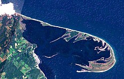
Notsuke Peninsula

Coordinates: 43°36′12″N 145°17′34″E / 43.603265°N 145.292732°E / 43.603265; 145.292732
From Wikipedia, the free encyclopedia
Notsuke Peninsula
野付のつけ半島はんとう
Notsuke Peninsula is located in Hokkaido
Notsuke Peninsula
Notsuke Peninsula
Notsuke Peninsula is located in Japan
Notsuke Peninsula
Notsuke Peninsula
Coordinates: 43°36′12″N 145°17′34″E / 43.603265°N 145.292732°E / 43.603265; 145.292732
LocationShibetsu & Betsukai, Hokkaidō, Japan
Dimensions
 • Length26 kilometres (16 mi)[1]
28 kilometres (17 mi)[2]
Official nameNotsuke-hanto and Notsuke-wan
Designated8 November 2005
Reference no.1552[3]

Notsuke Peninsula (野付のつけ半島はんとう, Notsuke hantō) is a peninsula on the east coast of Hokkaidō, Japan, with its northwestern base in Shibetsu and southeast tip in Betsukai. The name is derived from the Ainu for jawbone, notkeu (ノッケウ), purportedly due to the landform's visual resemblance to that of a whale.[4] The curved peninsula, the longest sandspit in the country, with a length of some 26 kilometres (16 mi) to 28 kilometres (17 mi), extends into the Nemuro Strait, which lies between Shiretoko Peninsula, Nemuro Peninsula, and the disputed island of Kunashiri in the Sea of Okhotsk;[2][5] it was formed by the deposition of sand sediment carried by the currents in the strait, and itself forms and largely encloses Notsuke Bay.[2] There remain on the peninsula traces of Satsumon culture pit dwellings, while during the Edo period samurai were stationed at a checkpoint controlling the crossing to Kunashiri.[1][6] It is said that from the Edo period to the beginning of the Meiji period there was a settlement known as Kiraku (キラク) at the tip of the peninsula, with streets lined with samurai residences and even pleasure quarters, but this is not shown on contemporary maps and is poorly attested in the literature.[5] Prominent features today include withered and eroded stretches of Sakhalin fir (Abies sachalinensis) at Todowara (トドワラ) and Mongolian oak (Quercus crispula) at Narawara (ナラワラ), while to be found in the Notsuke Peninsula Primeval Flower Garden near Notsukezaki Lighthouse towards the eastern tip are the Kamchatka lily, Japanese iris, sea pea, Rosa rugosa, Eriophorum vaginatum, and Hemerocallis esculenta (エゾカンゾウ).[7] The c.15 kilometres (9.3 mi) stretch of Hokkaido Prefectural Road Route 950 (ja) from the base of the peninsula to the nature centre is commonly known as the "Flower Road" (フラワーロード).[7] Together with Notsuke Bay, Notsuke Peninsula has been designated a Ramsar Site,[8] a Special Wildlife Protection Area,[2] and an Important Bird Area,[9] and forms part of Notsuke-Fūren Prefectural Natural Park.[10]

See also[edit]

References[edit]

  1. ^ a b 北海道ほっかいどう遺産いさん野付のつけ半島はんとう打瀬うたせぶね [Hokkaido Heritage: Notsuke Peninsula and Utase Boats] (in Japanese). Hokkaido Prefectural Government. 8 November 2011. Retrieved 1 April 2021.
  2. ^ a b c d "Notsuke-hanto and Notsuke-wan" (PDF). Ministry of the Environment. Retrieved 1 April 2021.
  3. ^ "Notsuke-hanto and Notsuke-wan". Ramsar Sites Information Service. Retrieved 23 July 2021.
  4. ^ (いいね!探訪たんぼうしずみゆくすなしま花鳥かちょう楽園らくえん 野付のつけ半島はんとう 北海道ほっかいどう別海べっかいまち標津しべつまち [A Sinking Sand Island and Paradise of Flowers and Birds, Notsuke Peninsula, Betsukai and Shibetsu, Hokkaido]. Asahi Shimbun (in Japanese). 4 July 2020. Retrieved 1 April 2021.
  5. ^ a b 野付のつけ半島はんとう [Notsuke Peninsula] (in Japanese). Betsukai Town. Retrieved 1 April 2021.
  6. ^ "Hokkaido Heritage: The Notsuke Peninsula and the Utase Boats (Betsukai and Shibetsu)" (PDF). Hokkaido Heritage Council. Retrieved 1 April 2021.
  7. ^ a b 野付のつけ半島はんとう [Notsuke Peninsula] (in Japanese). Nemuro Subprefecture. 14 March 2019. Retrieved 1 April 2021.
  8. ^ 野付のつけ半島はんとう野付湾のつけわん [Notsuke Peninsula and Notsuke Bay] (PDF) (in Japanese). Hokkaido Prefectural Government. Retrieved 1 April 2021.
  9. ^ "Notsuke, Odaitou". BirdLife International. Retrieved 1 April 2021.
  10. ^ 野付のつけふうはちすどうりつ自然しぜん公園こうえん [Notsuke-Fūren Prefectural Natural Park] (in Japanese). Hokkaido Prefectural Government. 8 April 2020. Retrieved 1 April 2021.