
Provinces of Japan

Provinces of Japan (
Provinces were established in Japan in the late 7th century under the Ritsuryō law system that formed the first central government. Each province was divided into districts (
The Provinces of Japan were replaced with the current prefecture system in the Fuhanken sanchisei during the Meiji Restoration from 1868 to 1871, except for Hokkaido, which was divided into provinces from 1869 to 1882. No order has ever been issued explicitly abolishing the provinces, but they are considered obsolete as administrative units. The provinces are still used in general conversation, especially in navigation and transportation, and referenced in products and geographical features of the prefectures covering their former territories.
History[edit]

The provinces were originally established by the Ritsuryō reforms as both administrative units and geographic regions. From the late Muromachi period, however, they were gradually supplanted by the domains of the sengoku daimyō. Under the rule of Toyotomi Hideyoshi during Azuchi–Momoyama period, the provinces were supplemented as primary local administrative units. The local daimyōs' fiefs were developed.[clarification needed][1]
Edo period[edit]
In the Edo period, the fiefs became known as han. Imperial provinces and shogunal domains made up complementary systems. For example, when the shōgun ordered a daimyō to make a census or to make maps, the work was organized in terms of the boundaries of the provincial kuni.[2]
Meiji period[edit]
At the Meiji Restoration, the han were legitimized as administrative units by the reform known as the Fuhanken Sanchisei, but they were gradually replaced by prefectures between 1868 and 1871 (urban prefectures were called fu and rural prefectures ken). Provinces as part of the system of addresses were not abolished but, on the contrary, augmented. As of 1871, the number of prefectures was 304, while the number of provinces was 68, not including Hokkaidō or the Ryūkyū Islands. The boundaries between the many prefectures were not only very complicated, but also did not match those of the provinces. Prefectures were gradually merged to reduce the number to 37 by 1881; a few were then divided to give a total of 45 by 1885. Adding Hokkaidō and Okinawa produced the current total of 47 prefectures.
Provinces are classified into Kinai (in or near the capital, then Kyoto) and seven or eight dō (routes, or circuits), collectively known as the Gokishichidō. However, dō in this context should not be confused with modern traffic lines such as the Tōkaidō from Tokyo to Kyoto or Kobe. Also, Hokkaidō in this context should not be confused with Hokkaidō Prefecture, although these two overlap geographically.
Today[edit]

No order has ever been issued explicitly abolishing the provinces, but they are considered obsolete. Nevertheless, their names are still widely used in names of natural features, company names, and brands. These province names are considered to be mainly of historical interest. They are also used for the names of items, including family names, most of which were popularized in or after the Edo period. Examples include sanuki udon, iyokan, tosa ken, Chikuzenni, and awa odori. Japan Rail and other railway stations also use them in names to distinguish themselves from similarly named stations in other prefectures, such as Musashi-Kosugi Station. The same is true for some city names, for example to distinguish Yamato-Koriyama, Nara from Koriyama, Fukushima. Simplified names of provinces (-shū) are also used, such as Shinshū soba and Kishū dog.
Some of the province names are used to indicate distinct parts of the current prefectures along with their cultural and geographical characteristics. In many cases these names are also in use with directional characters, e.g. Hoku-Setsu (
The districts are still considered prefectural subdivisions, but following mergers or divisions of the provinces they may be shared among several prefectures (such as the original Adachi District of Musashi, which is now divided between Adachi Ward in Tokyo and Kita-Adachi District in Saitama). Many of these old provincial districts have been dissolved as their chief towns have been merged into larger cities or towns. See individual prefecture pages for mergers and abolitions of districts.
The following list is based on the Gokishichidō (
Goki (五 畿, Five Provinces in Capital Region)[edit]

| Kinai | ||
| Tōkaidō | Tōsandō | Hokurikudō |
| San'indō | San'yōdō | Nankaidō |
| Saikaidō |
Kinai (畿内 , Capital Region)[edit]
- Yamashiro (Jōshū, Sanshū, Yōshū) (
山城 国 (城 州 ,山 州 , 雍州)) - Yamato (Washū) (
大和 国 (和 州 )) - Kawachi (Kashū) (
河内 国 (河 州 )) - Izumi (Senshū) (
和泉 国 (泉州 )) - Created in 716 from Kawachi Province as Izumi Gen (和泉 監 ). Although occupied by Kawachi Province in 740, in 757 the province divided again from Kawachi Province. - Settsu (Sesshū) (
摂津 国 (摂 州 ))
Shichidō (七道 , Seven Circuits)[edit]
Tōkaidō (東海道 , East Sea Circuit)[edit]
- Iga (Ishū) (
伊賀 国 (伊 州 )) – separated from Ise Province in 680 - Ise (Seishū) (
伊勢 国 (勢 州 )) - Shima (Shishū) (
志摩 国 (志 州 )) – separated from Ise Province at the beginning of the 8th century - Owari (Bishū) (
尾張 国 (尾 州 )) - Mikawa (Sanshū) (
三河 国 (三 州 )) - Tōtōmi (Enshū) (
遠江 国 (遠 州 )) - Suruga (Sunshū) (
駿河 国 (駿 州 )) - Izu (Zushū) (
伊豆 国 (豆 州 )) – separated from Suruga Province in 680 - Kai (Kōshū) (
甲斐 国 (甲州 )) - Sagami (Sōshū) (
相模 国 (相州 )) - Musashi (Bushū) (
武蔵 国 (武 州 )) – Transferred from Tōsandō to Tōkaidō in 771 - Awa (Bōshū, Anshū) (
安房 国 (房州 ,安 州 )) – Divided from Kazusa Province in 718. Although re-joined to Kazusa Province in 741, separated from Kazusa Province again in 781 - Kazusa (Sōshū) (
上総 国 (総 州 )) – divided from Fusa Province (総 国 ) in the 7th century - Shimōsa (Sōshū) (
下総 国 (総 州 )) – divided from Fusa Province in the 7th century - Hitachi (Jōshū) (
常陸 国 (常 州 ))
Tōsandō (東山 道 , East Mountain Circuit)[edit]
- Ōmi (Gōshū) (
近江 国 (江 州 )) - Mino (Nōshū) (
美濃 国 (濃 州 )) - Hida (Hishū) (
飛騨 国 (飛 州 )) - Shinano (Shinshū) (
信濃 国 (信州 )) - Kōzuke (Jōshū) (
上野 国 (上 州 )) – divided from Keno Province (毛 野 国 ) during the 4th century - Shimotsuke (Yashū) (
下野 国 (野 州 )) – divided from Keno Province during the 4th century - Dewa (Ushū) (
出羽 国 (羽 州 )) – broke Dewa District in Echigo Province and create Dewa Province in 712. On October of the same year, Mogami and Okitama Districts in Mutsu Province merged into Dewa Province. - Mutsu (Ōshū, Rikushū) (
陸奥 国 (奥州 ,陸 州 )) – split off from Hitachi Province in the 7th century
Hokurikudō (北陸 道 , North Land Circuit)[edit]
- Wakasa (Jakushū) (
若狭 国 (若州 )) - Echizen (Esshū) (
越前 国 (越 州 )) – broke off from Koshi Province (越 国 ) during the end of the 7th century - Kaga (Kashū) (
加賀 国 (加州 )) – divided from Echizen Province in 823 - Noto (Nōshū) (
能登 国 (能 州 )) – divided from Echizen Province in 718. Although occupied by Etchu Province in 741, divided from Etchū Province in 757 - Etchū (Esshū) (
越 中国 (越 州 )) – broke off from Koshi Province during the end of the 7th century - Echigo (Esshū) (
越後 国 (越 州 )) – broke off from Koshi Province during the end of the 7th century - Sado (Sashū, Toshū) (
佐渡 国 (佐 州 ,渡 州 )) – although occupied by Echigo in 743, divided from Echigo in 752
San'indō (山陰 道 , Mountain's Shady Side Circuit)[edit]
- Tanba (Tanshū) (
丹波 国 (丹 州 )) - Tango (Tanshū) (
丹後 国 (丹 州 )) – divided from Tanba in 713 - Tajima (Tanshū) (
但馬 国 (但 州 )) - Inaba (Inshū) (
因幡 国 (因 州 )) - Hōki (Hakushū) (
伯耆 国 (伯 州 )) - Izumo (Unshū) (
出雲 国 (雲 州 )) - Iwami (Sekishū) (
石見 国 (石 州 )) - Oki (Onshū, Inshū) (
隠岐 国 (隠 州 ))
San'yōdō (山陽 道 , Mountain's Sunny Side Circuit)[edit]
- Harima (Banshū) (
播磨 国 (播州 )) - Mimasaka (Sakushū) (
美作 国 (作 州 )) – divided from Bizen Province in 713 - Bizen (Bishū) (
備前 国 (備州)) – broke off from Kibi (吉備 国 ) during the 2nd half of the 7th century - Bitchū (Bishū) (
備中 国 (備州)) – broke off from Kibi Province during the 2nd half of the 7th century - Bingo (Bishū) (
備後 国 (備州)) – broke off from Kibi Province during the 2nd half of the 7th century - Aki (Geishū) (
安芸 国 (芸 州 )) - Suō (Bōshū) (
周防 国 (防 州 )) - Nagato (Chōshū) (
長門 国 (長州 ))
Nankaidō (南海 道 , South Sea Circuit)[edit]
Equivalent to Shikoku and its surroundings, as well as a nearby area of Honshu
- Kii (Kishū) (
紀伊 国 (紀州 )) - Awaji (Tanshū) (
淡路 国 (淡 州 )) - Awa (Ashū) (
阿波 国 (阿 州 )) - Sanuki (Sanshū) (
讃岐 国 (讃 州 )) - Iyo (Yoshū) (
伊予 国 (予 州 )) - Tosa (Doshū) (
土佐 国 (土 州 ))
Saikaidō (西海 道 , West Sea Circuit)[edit]
Equivalent to Kyushu and its surroundings
- Buzen (Hōshū) (
豊前 国 (豊 州 )) – broke off from Toyo Province (豊国 ) at the end of the 7th century - Bungo (Hōshū) (
豊後 国 (豊 州 )) – broke off from Toyo Province at the end of the 7th century - Chikuzen (Chikushū) (
筑前 国 (筑州)) – broke off from Tsukushi Province (筑紫 国 ) until the end of the 7th century - Chikugo (Chikushū) (
筑後 国 (筑州)) – broke off from Tsukushi Province until the end of the 7th century - Hizen (Hishū) (
肥前 国 (肥 州 )) – broke off from Hi Province (火 国 ) until the end of the 7th century - Higo (Hishū) (
肥後 国 (肥 州 )) – broke off from Hi Province until the end of the 7th century - Hyūga (Nisshū, Kōshū) (
日向 国 (日 州 ,向州 )) – earlier called Kumaso Province (熊 曾国) - Ōsumi (Gūshū) (
大隅 国 (隅 州 )) – divided from Hyūga Province in 713 - Satsuma (Sasshū) (
薩摩 国 (薩州)) – divided from Hyūga Province in 702 - Iki (Isshū) (
壱岐 国 (壱 州 )) – officially Iki no Shima (壱岐 嶋 ) - Tsushima (Taishū) (
対馬 国 (対 州 )) – officially Tsushima no Shima (対 馬嶋 )
Hachidō (八道 , Eight Circuits)[edit]
.svg)
Hokkaidō (北海道 , North Sea Circuit)[edit]
Equivalent to Hokkaido and its surroundings. Originally known as the Ezo Region, before being renamed and organized as 11 provinces (1869–1882).
- Oshima (
渡島 国 ) - Shiribeshi (
後志 国 ) - Iburi (
胆振 国 ) - Ishikari (
石狩 国 ) - Teshio (
天塩 国 ) - Kitami (
北見 国 ) - Hidaka (
日高 国 ) - Tokachi (
十勝 国 ) - Kushiro (
釧路 国 ) - Nemuro (
根室 国 ) - Chishima (
千 島国 ) - After the Treaty of Saint Petersburg (1875), Japan added north of Urup Island and placed Uruppu (得 撫 郡 ), Shimushiru (新知 郡 ), and Shumushu (占 守 郡 ) Districts.
Gallery[edit]
-
 Borders of the provinces from the Kamakura period until 1868.
 -
 Map of Japan at the end of the Edo period published in the United States in 1855.
 -
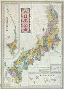 Meiji period map of Japan's provinces from ca. 1880s, after their replacement with the prefectures.


See also[edit]
- Code of Taihō
- Magiri
- Kokushi (officials)
- Demographics of Japan before Meiji Restoration
- Ritsuryō
- Han (administrative division)
- Samurai
Notes[edit]
- ^ Mass, Jeffrey P. and William B. Hauser. (1987). The Bakufu in Japanese History, p. 150.
- ^ Roberts, Luke S. (2002). Mercantilism in a Japanese Domain: the merchant origins of economic nationalism in 18th-century Tosa, p. 6; excerpt, "Imperial provinces "remained on the cultural map as commonly used definers of territorial regions called kuni ... because when the shogun ordered populations registers and maps to be made, he had them organized along the borders of the provincial kuni. This has been interpreted as important evidence of the shogun's styled role as a servant of the emperor, one of the important means by which he legitimized his authority."
References[edit]
- Nussbaum, Louis-Frédéric and Käthe Roth. (2005). Japan encyclopedia. Cambridge: Harvard University Press. ISBN 978-0-674-01753-5; OCLC 58053128
External links[edit]
Detailed maps of the provinces at different times can be found at: