The coast from St Clair to St Kilda is always changing, and is shaped by powerful natural forces like waves, winds, tides, and currents.
The beach can rise and fall by as much as three and a half metres over a year and by more than a metre overnight, and the environment is one of the most exposed urban coastal locations in New Zealand. The speed that the environment changes is part of what’s so special about the place.
These rapid and dramatic changes in the beach are caused mostly by storms that erode the beach and dune and move sand away from the shore. Whilst erosion and sand loss can be quick, the recovery of the beach occurs much more slowly over days, weeks, and months as sand is moved back on to the beach by calmer conditions. These changes are what give the coast its dynamic character.
With sea levels rising and coastal storms occurring more often, we expect the beach will change even more rapidly and we expect our current defences (the dunes, geobags, and sea wall) to become more vulnerable to storms and erosion. The beach already struggles to recover and rebuild itself at certain times of the year. Given that the time between storms will be reduced, we also expect that it will become even more difficult for the beach and dunes to recover after storms.
Some of the most important natural processes that shape the St Clair to St Kilda coast are waves, winds, tides, and currents. The sections below help to explain what these processes are and how they influence the St Clair – St Coast.
-
Waves
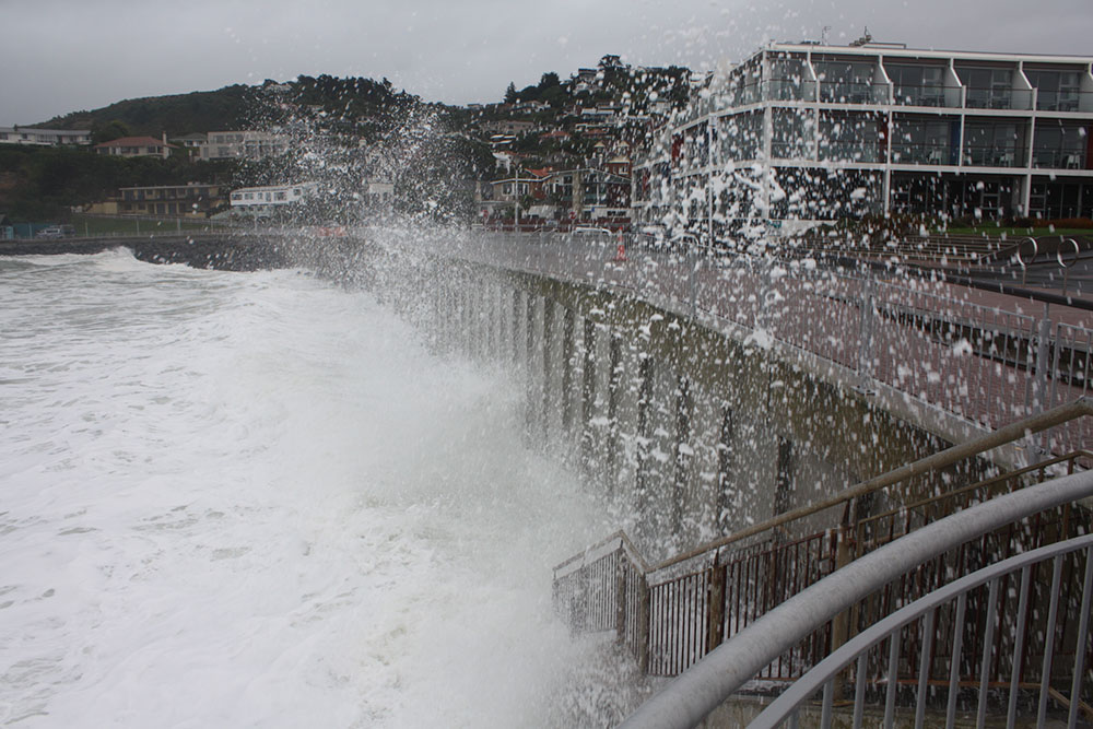
While the St Clair – St Kilda coast can experience calm wave conditions favourable to swimmers, it is also common for large waves to erode the beach and impact infrastructure, such as the sea wall and geobags. Whilst spectacular, large waves can present a safety hazard for people in the water and along the esplanade.
Generally, larger waves occur in winter and have a greater potential to remove sand from the beach (erosion), while calmer conditions are more typical of the warmer months and can often be associated with raising the beach (accretion). This seasonal cycle of beach lowering and raising is very important. When the beach is low, land and infrastructure is at greater risk of damage and the beach is generally less accessible for people.
-
Winds
Winds influence the size and direction of waves that arrive at the beach, and winds drive many of the processes that shape the coastal environment. The most common strong winds at this coast come from the south-west. These winds are responsible for blowing sand from the beach into the sand dunes, and at times across Kettle Park and John Wilson Ocean Drive (shown below). Wind is the key driver that creates large waves, so the best time to see large waves at the beach is during a strong southerly gale. Waves coming from the south can travel across many thousands of kilometres before arriving at the beach, this means they can grow very big during this journey.

-
Tides
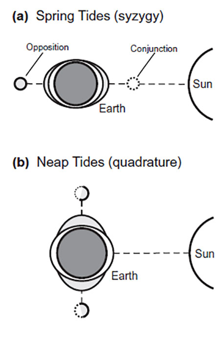
The fluctuating gravitational pull from the Sun and Moon cause sea levels to rise and fall as Earth rotates. These are our tides.
Depending on the location of Earth relative to the Sun and Moon, sea levels rise and fall to different levels throughout the year. The moon varies in distance from Earth as part of its lunar cycle (daily) and the Sun varies in its distance over the course of a year. Interestingly, the Moon has more than twice the gravitational pull of the Sun, as it is located much closer to Earth.
Twice each month we experience larger tides when the water comes further up the beach, these are called Spring Tides. Spring tides can cause the sea level to be more than 60cm higher at St Clair Beach than during Neap tides, which are lower tides. Spring tides occur when the Sun and Moon are aligned, this provides a stronger pull on Earth’s waters, causing our tides to be more extreme. King Tides which are even larger, occur much less often. King tides only occur when the Sun and Moon are aligned at the same time as Earth is closest to the Moon (known as the perigee).
When high tides, spring tides, or king tides occur at the same time as stormy (windy) conditions, the potential for erosion and damage to infrastructure is increased. This is because waves are closer to the shore when they break, so there is more energy available to cause erosion. It is predicted that climate change will cause stormy conditions to occur more frequently, this means that strong winds and large tides might occur at the same time more often.
-
Currents
Alongshore currents are formed when waves make contact with the beach at an angle and water moves along the beach. At St Clair and St Kilda this is most common during south-westerly winds and results in currents that mobilise and transport sand from west to east (i.e. from St Clair towards St Kilda).
Easterly winds can generate currents that result in the opposite effect where sand is transported east to west, although these conditions occur less frequently.
In the past wooden structures known as groynes have been placed on St Clair Beach to trap sand moved by these alongshore processes. The remains of the last groyne are the famous poles, seen in many photos around Dunedin (photo below).

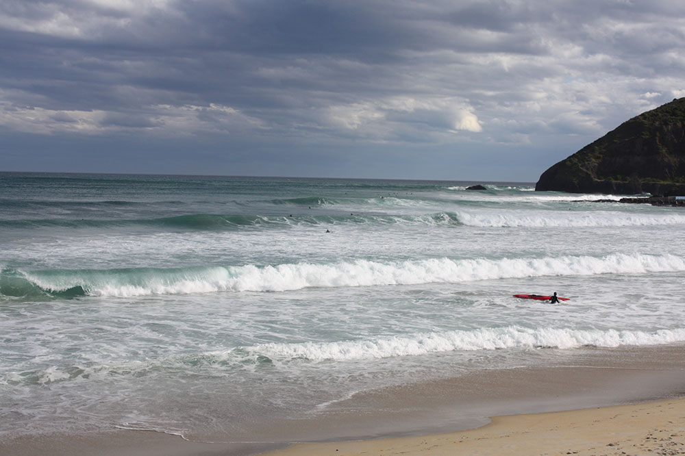
Currents can also pull sand directly off the beach (cross-shore erosion). These conditions are very common at St Clair and St Kilda Beaches and are most common when waves approach the beach head-on. These conditions can result in the formation of rip currents. Rip currents are areas of deeper water where water and sand is pulled away from the beach. Rip currents are a key driver of localised erosion and pose a significant threat to swimmers.
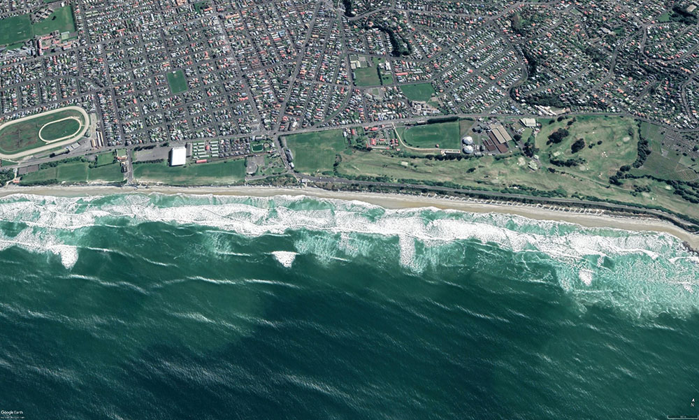
The lighter coloured water in this image shows the location of cross-shore currents – the water is a lighter shade because it is containing mobile sand.
-
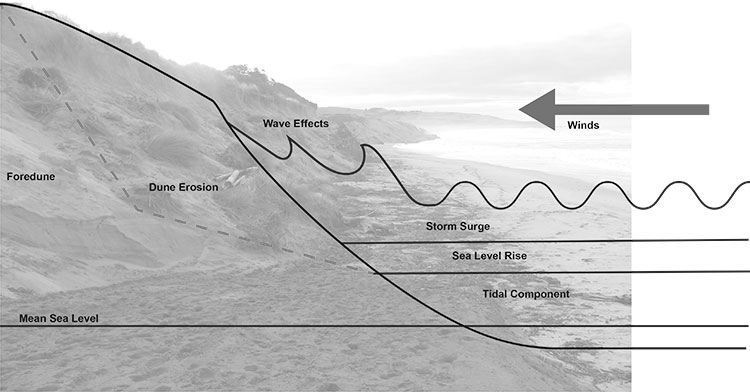
Storm surge
Storm surge is a temporary rising of the sea level as a result of wind and atmospheric pressure change.
Next time you are watching the news, take a look at the air pressures on the weather map. The lower the air pressure, the less downward force is being placed on the sea, and this means the sea level will be higher than it would be otherwise. Higher air pressures mean lower sea levels.
Storm surge is a key driver of erosion at St Clair and St Kilda and results in lowering of the beach and damage to land and infrastructure. When combined with large tides and sea level rise, storm surge to the beach like a heavy rainfall event is to South Dunedin.